Saturday, September 18, 2010

September 18, 2010 Sharp Top

With the weather nice, the club (today Rekha, Deept, and Jody, though we ran into Van on the hike) set out for Sharp Top for a hike with a winery stop at LeoGrande in Goode, VA. Sharp Top is a fairly short, but steep hike (rising 1,370 feet over 1.6 miles) where route 43 meets the Blue Ridge parkway that was once thought to be the tallest mountain in Virginia. For those not interested in the hike, but interested in the view, there's also a bus that can take you to the top while the weather holds. Peaks of Otter Lodge is at the base, where the club stopped for lunch at the end.
Click through to see photos from the hike.

Sign at the trail head.

Rekha hiking near the bottom of the trail.

Deept hiking next to some boulders.

A view from part way up Sharp Top

Another view along the hike.

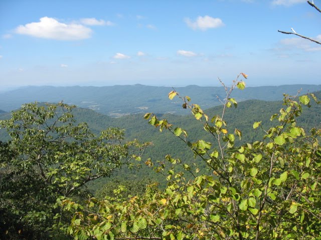
Yet another great view.

Deept and Rekha hiking.

Jody resting at Buzzard's Roost. When asked by hikers climbing up how much farther the hike is, Jody likes to give his estimate, but then point down at his shirt and say "But the log flume ride at the top makes it all worth it."

View from along the hike.

An outcropping at Buzzard's Roost (the little side spur near the top, which is MUCH less crowded and which has way fewer bugs than the top of Sharp Top.

A boulder balanced on top of an outcropping on Buzzard's Roost. Looks like a giant-size cairn.


Another mountain (don't know the name).

Rekha and Deept are doing ... err... something.

Shelter at the top of Sharp Top.

Sign at the top.

Looking out from near the top of Sharp Top.

Rekha taking a break at the top.

Deept looking stern.

Photos from LeoGrande to be posted when they're available

Read More!

Saturday, March 20, 2010

March 20, 2010: Crabtree Falls

For the first weekend of Spring, the weather decided to cooperate (temps in the 70s) so the club set out for Crabtree Falls as the first hike of the year. Preethi, June, Fritz, Franz, and Jody didn't get away from Lynchburg until after 2 PM and grilling was already planned for afterwards, so a winery tour was not considered for this trip. :(

Crabtree Falls is a series of photogenic waterfalls in Nelson County on Route 56. We began at the bottom of the falls and hiked to the top (about 2 miles each way).

Click through to see photos from the hike.

At the bottom, there's an ominous warning that 23 people have died on the trail from stepping out too far onto slippery moss-covered rocks.

Franz and June. At the beginning of the hike (to the first switchback), the trail is paved and has a gentle slope.

A cascade near the bottom of the trail.

There's quite a few stairs on the hike (some wooden, some stone), but it's not really that stenuous.

Jody, Fritz, June, and Preethi at a switchback next to the falls. The trail is a sequence of switchbacks on the right side of the falls, so there's lots of these landings along the way to rest or just to take a goofy picture.

Preethi and Fritz at a switchback.

Fritz, Preethi, and June emerge from a little cave on the side of the trail.

Hiking up the trail. Lots of people were out while we were hiking up, though noticeably fewer when we were coming down.

Yet another switchback, yet another spectacular waterfall.

About 2/3 of the way up.

Close to the top.

June posing in front of a portion of the falls.

Fritz's turn to pose for a picture.

Franz is King of the World!!! Or at least standing on a boulder.

Looking out over the North Fork (Tye River) Valley from the top of the falls.

Franz at the top of the falls.

While we were sitting at the top of the falls, an eagle alighted on a branch close to us.

Fritz was quite tired after the hike up. After resting in the shade for about 30 minutes (and having some water and ham), he was eager to start hiking down.

Fritz, Preethi, June, and Jody on a platform at the top of the falls.

Snow. Even though it was in the 70s, this was a little reminder that it was also the last day of Winter.

Hiking back down towards one of the cascades.

Back to parking lot and off to the grill out.

Read More!

Sunday, June 7, 2009

June 7, 2009: Cave Mountain Lake

In a recurring theme, on the 7th, the Wine-Hiking Club intended to go to the Devil's Marbleyard with a later visit to the Fincastle Winery, but because the parking lot for the Devil's Marbleyard was full everytime we visited with warning signs not to park on the grass, we diverted to Cave Mountain Lake and ended up not making it to Fincastle Winery because we visited Escape from Dinosaur Kingdom which we had seen advertised at the the White Rock Winery on a previous hike.

Cave Mountain Lake is a man-made lake just off of 501, north of the Blue Ridge Parkway and south of Natural Bridge nestled in the Blue Ridge mountains. It's primarily used as a recreational area (there's a fee to enter) for swimming and fishing with lots of space for camping / RVing with several nature trails. We followed a loop trail around the lake which was a light, mostly level hike on a well-maintained trail about 1.5 miles long with lots of views of the lake. It appears that the trail had washed out below the dam so we had to ford a knee-deep creek at one point.

Cave Mountain Lake.

The following are pictures from the hike. Pictures from Escape from Dinosaur Kingdom are in this facebook gallery.

Beginning the hike around Cave Mountain Lake. It's primarily a recreational area.

A stream that flows into Cave Mountain Lake.

Vineet and Rekha examine the closest thing we had to a trail head. This was actually for a nature trail that launched off of the lake loop trail that we hiked.


A view of the lake from the loop trail.

It was a very well-maintained trail with bridges over the little streams that flowed into the lake.

Vineet and Van hiking up the trail.

A view of the lake from the lake side. At various points along the trail, there were short spurs down to the lake for fishing.

The lake has a beach area where local kids come to swim. The sand looks like it was trucked in. I assume the swim zones are there to keep the fishermen separated from the swimmers.
Rekha and Vinnet on one of the fishing jetties on the other side of the lake.

Some interesting mushrooms along the trail.

The lake was made by this dam at the far end of the lake. We had seen quite a bit of rain over the last few days, so water was flowing over the center spillway.

The bottom of the dam.

I don't know if the trail was washed out or if there was never a crossing, but we had to cross the stream from the dam outflow to continue on. At this point, Van, Rekha, and I had crossed and were waiting on Van.

Still waiting on Van.

Here he comes.

Another view of the lake from the trail.

After crossing the stream and climbing back up the hill, we made it to the other side of the dam.

There were a couple kids who swam in the lake right next to the spillway.

After visting the lake, we returned to the Devil's Marbleyard where the parking lot was again full. We then bailed on that hike and drove up the road (about 10 miles) to Natural Bridge with the intent of visiting Escape from Dinosaur Kingdom. Tickets had to be purchased in the Natural Bridge visitors center where this umm tasteful display was located.

It was a package deal - a dinosaur kingdom ticket comes with a ticket to the monster museum. Unfortunately, the batteries in my camera ran out before the monster maze, so there were no pictures taken there.

A picture of an artist's rendition of the Natural Bridge on a T-shirt in the visitor's center. That's as close as we got to the actual bridge.

Wine wasn't completely a lost cause as the Natural Bridge visitor's center had a selection from a local winery. No tasting room though. :(

Close up of the bottles.

Rekha found a rather unique cork next to the display.

I didn't see anything else that looked like a bridge, so surely this must be the Natural Bridge. ;)

A dam on the James River that we saw along the way.


Read More!